Maps
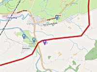
It is essential to understand the route of the proposed transmission line through the Towy Valley. It is shown on these maps.
Information about the route is derived from GreenGEN Cymru's own maps (see below) and followed as closely as possible. As the planning process continues it is very possible that some details may change.
The interactive maps are heavily data intensive and may be slow to load.
-
Interactive map of the preferred route
The route information in the above maps plotted as an interactive map.
Includes place markers of some notable locations that may be impacted. The background map can be changed, showing different aspects of the landscape.
-
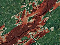
Visual Impact of Pylons - Map
Interactive map of the proposal's preferred route showing visual impact of the pylons on the landscape. For any selected location the red shading shows the number of pylons that will be seen, the darker the shade equals more pylons.
-
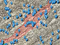
Sites of historical interest near the proposed route
Shows Cadw recorded historical locations in the Towy Valley and the route corridor containing both preferred and less preferred possible options.
The Towy Valley and Wales as a whole is rich in historical and cultural locations, which should certainly be treated and preserved with care.
-
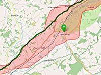
Via Julia Montana Roman road
The Via Julia Montana Roman road also has significant historical importance and its route runs along the Towy Valley, lying in part within the proposed construction corridor.
-
Bute Energy/Green GEN maps
It's important to consult Bute/GreenGEN's own maps relating to the project. They can be found on their website (links open in new tab):
Preferred route map
Nant Mithil Energy Park to Aberedw Hill
Aberedw Hill to Llangammarch Wells
Llangammarch Wells to Llandovery
Llandovery to Llandeilo
Llandeilo to Llandyfaelog
The GreenGen Vyrnwy-Frankton project
`